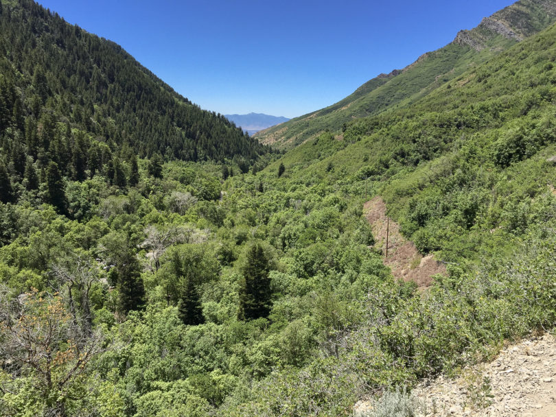
The lower half of Pipeline Trail is relatively flat and descends at a much lower rate than to road, as it heads West, so when you reach the end of the trail you’ll still be 567 feet above the road. From there, do a steep and relatively technical descent on Rattlesnake Gulch back down to Mill Creek Rd. Before your final ascent, consider the option of a quick out and back, 2 mile round trip, out to a great overlook of Salt Lake City. Zoom in on the map above for a better look.
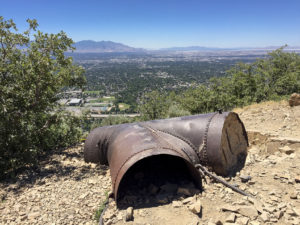
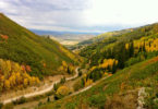
View of Greater Salt Lake City from the overlook out-and-back of the Pipeline Traill up Mill Creek.
There are two other points where you can descend off Pipeline Trail down to Mill Creek. Burch Hollow and Church Creek divide Pipeline roughy into thirds. You’ll hit Burch Creek first, then Church Creek. Both exits are about level with Mill Creek Road and offer fast and easy exits if you really need to get off the trail. Stick with Rattlesnake Gulch for the only challenging descent.
Optional Routes
Pipeline only offers a few route options. Like a handful of other Wasatch Front trails, there aren’t a ton of other trails in the vicinity that offer diversity and longer, half-day rides.
Pipeline happened to be my neighborhood ride for a season. I hate putting my bike in my car and I hate paying for parking—its $3 per car up Mill Creek. I also prefer loops, so my typical route starts by riding 6.2 miles up the paved Mill Creek from Wasatch Blvd to the trailhead and then down the entire trail to Rattlesnake Gulch ending with a faster-than-car ride down to road back to Wasatch Blvd. (Note: annual Mill Creek parking passes are on $39 and give you x-country ski access in the winter.)
Most of you won’t live in the neighborhood, so plan on parking at the UTA park and ride lot on Wasatch Blvd and 3900 S. If you add the overlook out and back, from the top of Rattlesnake Gulch trail, the ride totals 16.8 miles and a total elevation gain of 2,000 feet.
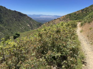
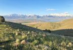
View of Greater Salt Lake City from the mid-point of the Pipeline Trail up Mill Creek.
Post Ride Refreshments
For those of you who want to enjoy a beer or cocktail immediately after your ride, this next option is for you. Park at the seasonal gate (closed in early spring and in the fall) on Mill Creek and ride approximately 1.4 miles up to Pipeline. Then do an out and back, cutting the return leg short and exiting at Burch Creek for a short paved climb back to your vehicle. There are a ton of national forest picnic sites and you will be parked right right next to one. Grab your cooler, find a spot and enjoy your reward of a cold beer as you listen to Mill Creek gurgle past. I recommend the Farmhouse Ale from 2 Row Brewing in West Valley, Utah. Pick it up at the State Liquor Store before your ride—the one near REI on 3300 S—and put it on ice!
If you want a bit more culture, hit up Log Haven for a drink at the bar. Log Haven is about .9 miles below the winter gate. You may not be hungry, but Utah’s pesky restaurant liquor laws require you eat if you want alcohol. Order some fries and call it good.
The last option I’ll offer adds Pipeline to a larger route that begins with a Guardsman Pass shuttle drop, with a pickup off Wasatch Blvd in Mill Creek. Learn more about the Wasatch Crest to Mill Creek Shuttle Loop.
Please comment and let us know how we can improve this site. Our goal, as always, is not to just tell you about the ride, but to help you make an event out of the ride.
Cheers.